Volume 6
-
No. 12 December 2013
The Indian Ocean Dipole is a key mode of interannual climate variability influencing much of Asia and Australia. A Review suggests that in response to greenhouse warming, mean conditions of the Indian Ocean will shift towards a positive dipole state, but with no overall shift in the frequency of positive and negative events as defined relative to the mean climate state. The image shows a devastating bushfire in the small township of Tonimbuk, 90 km east of Melbourne, Australia, in February 2009, following severe austral spring rain deficits between 2006 and 2008, three consecutive years of positive Indian Ocean Dipole events.
Review article p999
IMAGE: ANDREW BROWNBILL/AAP
COVER DESIGN: DAVID SHAND
Focus
-
No. 11 November 2013
Porphyry ore deposits supply much of the copper, molybdenum, gold and silver used by humans. A review of the main processes that trigger porphyry ore formation suggests that sulphide saturation of the magmas that supply the metals could be the overriding mechanism that helps control the temporal and spatial distribution of the ore deposits. The image shows the view across the Ujina porphyry copper deposit, Collahuasi district, Chilean Andes, looking towards the Bolivian border. Review Article p917
IMAGE: JAMIE WILKINSON
COVER DESIGN: DAVID SHAND
Focus
-
No. 10 October 2013
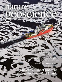
During glacial periods, ice sheets covered continental margins through much of Arctic North America, Greenland and western Eurasia. Marine structures suggest that an ice sheet up to a kilometre in depth periodically covered the East Siberian continental shelf as well. The image shows the Korean icebreaker Araon conducting a swath bathymetric survey on the Arctic Ocean.
Letter p842; News & Views p807
IMAGE: SEUNG PIL HAN
COVER DESIGN: DAVID SHAND
-
No. 9 September 2013
The remote detection of surface water indigenous to the Moon has proved difficult because of alternative sources, such as the solar wind. Spectroscopic observations of hydroxyl-bearing materials in Bullialdus Crater by the Chandrayaan-1 spacecraft are consistent with indigenous magmatic water that was excavated by impact from the lunar interior. The image shows an oblique view of Bullialdus Crater, taken from the west, about 74 km above the lunar surface, and looking east at the eastern crater wall (north is to the left). The central peak towers 1.1 km above the flat crater floor.
Letter p737
IMAGE: NASA
COVER DESIGN: DAVID SHAND
Insight
-
No. 8 August 2013
The Lusi mud eruption in Indonesia has been ongoing since 2006. Numerical simulations show that a parabolic-shaped layer in the rock surrounding the site of the Lusi eruption could have amplified and focussed incoming seismic energy from an earthquake, which then triggered the mud eruption. The image shows mud oozing out of the Lapindo well in the district of Sidoarjo, Indonesia, on Monday, 18 September 2006.
Letter p642; News & Views p592
IMAGE: BLOOMBERG, GETTY IMAGES
COVER DESIGN: DAVID SHAND
Focus
-
No. 7 July 2013
Flow in the deep mantle is thought to create textures in the high-pressure mineral post-perovskite. Laboratory simulations of the transformation between lower-pressure perovskite and post-perovskite show that postperovskite can also inherit textures from the perovskite phase, and vice versa. This image shows an electron diffraction pattern with strong crystallographic alignment between perovskite and post-perovskite.
Letter p575; News & Views p516
IMAGE: DOBSON ET AL.
COVER DESIGN: DAVID SHAND
-
No. 6 June 2013
Carbon is carried into the Earth at subduction zones. Geochemical analysis of subducted sediments now exhumed in Alpine Corsica, France, reveal the formation of graphite during shallow subduction, implying that carbonate transformation to graphite aids transport into the deeper Earth. This image shows a contact between hydrothermally altered mantle rocks and blueschist metasediments in Alpine Corsica, France.
Letter p473
IMAGE: ALBERTO VITALE BROVARONE
COVER DESIGN: DAVID SHAND
-
No. 5 May 2013
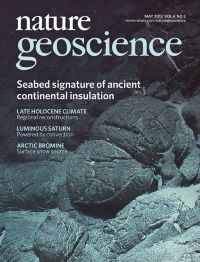
The continents are thought to insulate and heat the underlying mantle. Geochemical analyses of lava samples formed at a mid-ocean ridge in the Atlantic Ocean immediately after continental break-up show that the mantle was up to 150 °C hotter than today and took about 70 million years to cool. The image shows pillow lavas — which record the chemical composition of the melts — at the southern Mid-Atlantic Ridge at 9° 34' S.
Letter p391; News & Views p332
IMAGE: MARUM, UNIV. BREMEN, GERMANY
COVER DESIGN: DAVID SHAND
-
No. 4 April 2013
Assessing potential future carbon loss from tropical forests is important for evaluating the efficacy of programmes for reducing emissions from deforestation and degradation (REDD). An exploration of results from 22 climate models in conjunction with a land surface scheme suggests that in the Americas, Africa and Asia, the resilience of tropical forests to climate change is higher than expected, although uncertainties are large. The image shows a tropical rainforest canopy.
Letter p268
IMAGE: THINKSTOCK/ PHOTODISC
COVER DESIGN: DAVID SHAND
-
No. 3 March 2013
Antarctic Bottom Water fills much of the global abyssal ocean, and is known to form in three main sites in the Southern Ocean. Data from instrumented elephant seals and moorings suggest an additional source of bottom-water formation in the Cape Darnley polynya that is driven by sea-ice production. The image shows an instrumented Weddell seal, deployed together with the Southern elephant seals in the study.
Article p235: News & Views p166
COVER IMAGE: IAIN FIELD
COVER DESIGN: DAVID SHAND
-
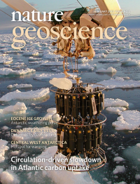
No. 2 February 2013
Uptake of atmospheric carbon dioxide in the subpolar North Atlantic Ocean declined rapidly between 1990 and 2006. An analysis of oceanographic data suggests that the slowdown of the meridional overturning circulation was largely responsible. The image shows sampling near the southeastern tip of Greenland aboard research vessel Thalassa, 18 June 2002.
Article p146
IMAGE: IFREMER-OVIDE
COVER DESIGN: DAVID SHAND
-
No. 1 January 2013
The recurrence times of great Himalayan earthquakes are difficult to assess because they rarely rupture the surface. Field mapping and 14C dating of offset fluvial deposits are used to identify two great Himalayan quakes that ruptured the surface along the main plate boundary fault in AD 1255 and 1934. The image shows the Sir Khola river-cut cliff looking east. Thrust fault F4, outlined by a narrow band of thin dark gouge, is seen to cut obliquely deformed grey Siwalik siltstones. Shyam Bogati, from Cheru village in southeastern Nepal, is refreshing the cliff face.
Article p71; News & Views p19
IMAGE: L. BOLLINGER
COVER DESIGN: DAVID SHAND
Focus